Sunday, March 22, 2009

Picasa Web Albums - Don


Picasa Web Albums - Don
The following slide show is one proposal to begin the Black's Building reconstruction project. This is a multistage project that will begin with a volunteer organization. The stages will be centered around the following: The original portion of the building from the front on Minor St. to the Sandstone wall in the back, The back portion of the building will be torn down and an outside covered patio will be constructed in this area, The construction of the parking lot in the rear of the historic buildings, The addition of a entry sign and decorative details of the building and the patio area, The creation of an entrance into the Franco-American Hotel, Please feel free to ad comments and suggestion to this proposal.

Sunday, February 15, 2009

Bank Building


This SketchUp work in in progress.
The Bank Building that sits on the corner of Miner and Third St. in Yreka. There has been a Bank Building here since the early days of Yreka. The first bank was a one story building. This building has gone through several changes in its history. This current rendering is close to what it look like today.

Sunday, February 8, 2009

Two new building


Two new building have now been added to the timeline. The Yreka County Court House of 1900 and the Martin & Irwing Empire Livery. This rendering represents 10 a.m. on the 8the of Feburary.

Thursday, November 13, 2008

Early Renders


Photos by
Don
Nov 13, 2008
Yreka, Ca USA
4 photos - 676 KB
Public
Rendering is the process where you add textures lighting and many additional subtleties. This process is a trial and error process. The process is an interesting blend between the technical and the aesthetic. The render software I'm using is called Kerkythea and is a free software.

Wednesday, November 12, 2008

1897 Yreka, CA Court House


This is a reconstruction of the Yreka, CA County Court House as it looked in 1897. This building with it's complex Victorian detail has taken quite a bit of research and time to develop. It is not quite finished at this time. However I thought I'd share how it is coming along. This structure is still standing however it is difficult to view because there is a large 1953 structure that was add on to the front of the building and many buildings have been built around it. The tower is no longer there.

Thursday, August 21, 2008

The Pashburg Store


The Pashburg Store was built by one of the original Yreka pioneers. It was originally a cigar store. The small building on the right was a bar. This area is now 4th street.

Wednesday, August 20, 2008

Building Evolutions


This slide show is to give you some idea of the type and extent of the changes I would like to see in the Google Earth Timeline. This may be too memory intensive for Google Earth to handel at this time. So I will also be experimenting with combinations and links between the following programs to accomplish the historical record I hope to display; Google Earth, SketchUp, Picasa, You Tube.

Tuesday, August 19, 2008

Yreka Google Earth


This image of The Historic District of Yreka shows references and beginning modeling. The references are the current day Google Earth image. The pink area is an overlay of a Sandborn Fire Map. The Sandborn maps were created every few years to show the plan view of every building in town for the fire department reference when called to a fire. The one shown is 1901. I worked with the overlay so that it matches the current Google Earth image. Next the basic rectangle shape for each building was created to get the general layout of the town in 1901. The next step is pull the building one at a time and create a detailed 3d model of the building during that period. References to recreate these building have come form several photographic records: The Siskiyou County Museum. Our Books, local individual collections, University of California Davis. Once the detailed 3d image of the building is placed back into Google Earth, It can be called back into SketchUp for further changes and updates then returned to Google Earth. This process has been developed so that this will be "Living Document".

Veiw of Yreka on Google Earth


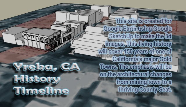
Google Earth is a program from Google that allows the viewer to travel anywhere on the face of Earth in cyber space. In this program one can map areas where they want to travel, See 3d building and features of almost any town, go to one of the National Parks, or just fly about the Earth to your whim and pleasure. If you haven't tried it, I suggest you give it a try. This image of Yreka, CA is taken from over 5000 feet in the air. You can see Mount Shasta in the upper left of the background.